


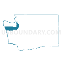
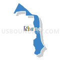
Water: Admiralty Inlet, Jefferson County, Washington
About
Outline

Summary
| Unique Area Identifier | 684528 |
| Name | Water: Admiralty Inlet |
| County | Jefferson County |
| State | Washington |
| Area (square miles) | 41.59 |
| Land Area (square miles) | 0.00 |
| Water Area (square miles) | 41.59 |
| % of Land Area | 0.00 |
| % of Water Area | 100.00 |
| Latitude of the Internal Point | 47.99504480 |
| Longtitude of the Internal Point | -122.66434300 |
Maps


Graphs
Select a template below for downloading or customizing gragh for Water: Admiralty Inlet, Jefferson County, Washington


Neighbors
Neighoring Voting District (by Name) Neighboring Voting District on the Map
- Voting District 106, Jefferson County, WA
- Voting District 401, Jefferson County, WA
- Voting District 501, Jefferson County, WA
- Voting District 502, Jefferson County, WA
- Voting District 701, Jefferson County, WA
- Voting District 702, Jefferson County, WA
- Voting District 705, Jefferson County, WA
- Water: Admiralty Bay, Island County, WA
- Water: Hood Canal, Jefferson County, WA
- Water: Hood Canal Leg 23, Kitsap County, WA
- Water: Oak Bay, Jefferson County, WA
- Water: Port Townsend Bay, Jefferson County, WA
- Water: Strait of Juan de Fuca, Jefferson County, WA
- Water: Strait of Juan de Fuca, Island County, WA
Top 10 Neighboring County Subdivision (by Population) Neighboring County Subdivision on the Map
- Discovery Bay-Port Townsend CCD, Jefferson County, WA (15,833)
- South Whidbey Island CCD, Island County, WA (13,630)
- Central Whidbey Island CCD, Island County, WA (12,458)
- Kingston CCD, Kitsap County, WA (11,392)
- Oak Bay-Port Ludlow CCD, Jefferson County, WA (10,092)
Top 10 Neighboring Place (by Population) Neighboring Place on the Map
- Port Townsend city, WA (9,113)
- Hansville CDP, WA (3,091)
- Port Ludlow CDP, WA (2,603)
- Marrowstone CDP, WA (844)
Top 10 Neighboring Unified School District (by Population) Neighboring Unified School District on the Map
- North Kitsap School District, WA (45,966)
- South Whidbey School District, WA (15,336)
- Port Townsend School District, WA (14,278)
- Chimacum School District, WA (11,350)
- Coupeville School District, WA (9,696)
Top 10 Neighboring State Legislative District Lower Chamber (by Population) Neighboring State Legislative District Lower Chamber on the Map
- State House District 10, WA (134,117)
- State House District 24, WA (132,679)
- State House District 23, WA (130,119)
Top 10 Neighboring State Legislative District Upper Chamber (by Population) Neighboring State Legislative District Upper Chamber on the Map
- State Senate District 10, WA (134,117)
- State Senate District 24, WA (132,679)
- State Senate District 23, WA (130,119)
Top 10 Neighboring 111th Congressional District (by Population) Neighboring 111th Congressional District on the Map
- Congressional District 2, WA (760,041)
- Congressional District 1, WA (739,455)
- Congressional District 6, WA (709,570)
Top 10 Neighboring Census Tract (by Population) Neighboring Census Tract on the Map
- Census Tract 9505, Jefferson County, WA (6,514)
- Census Tract 9506.01, Jefferson County, WA (6,299)
- Census Tract 9503, Jefferson County, WA (6,148)
- Census Tract 9504, Jefferson County, WA (3,944)
- Census Tract 9506.02, Jefferson County, WA (3,020)
- Census Tract 9922.01, Island County, WA (0)
- Census Tract 9901, Kitsap County, WA (0)